The North Atlantic Arc Home
Iceland • Faroe Islands • Shetland • Orkney • Norway
| The text and photos below are copied from a series of emails I sent to friends in 2005, while I was preparing to return to Shetland. |
|
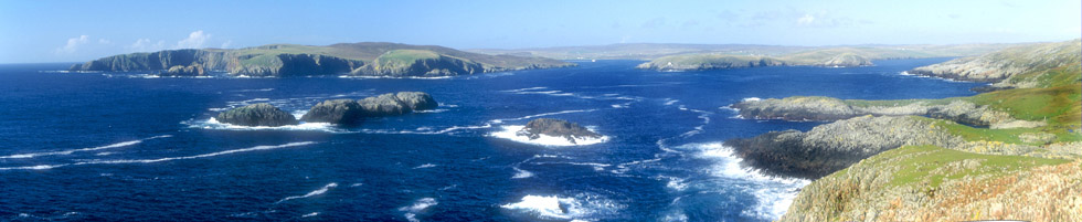
| In an odd corner of the main island, at the end of a dead-end road, is a scattering of houses that doesn't quite constitute a village. There is a ruin of a building that must at one time have been the village shop or post office or both, next to which is a very dusty, but perfectly serviceable, standard issue red phone box. Park your car and walk through a gate onto a farm track. A mile and a half away stand the shattered ruins of an Iron Age broch, not in itself much to look at. But its setting is spectacular, on a steep knoll atop cliffs overlooking Gruting Voe (Voe being the peculiarly Shetlander word for a fjord or bay). It was a stunning day, and I sat by the broch and fantasized about Linda, the lovely barmaid at The Lounge Bar back in Lerwick. Aside from a farmer riding a tractor about a mile away, I never saw another human on the walk. |
|
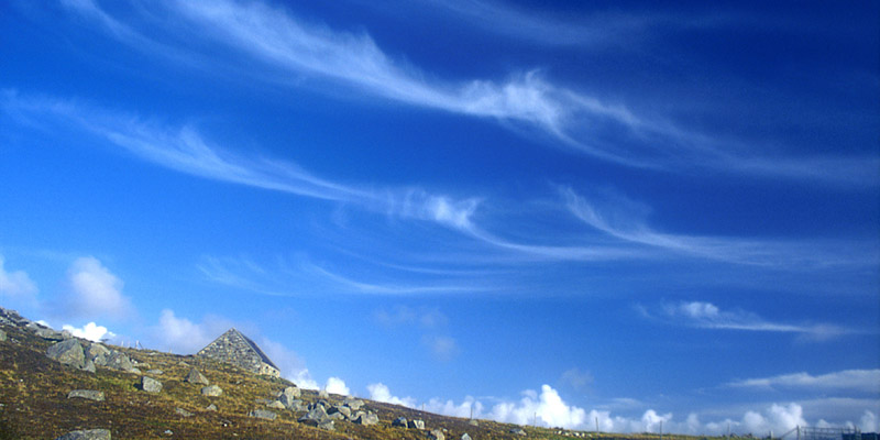
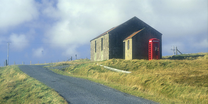
| Almost back to the gate, a stone house sits on the hill above the track. If memory serves, it is a meeting hall for a Protestant denomination unusual in Scotland--Baptists, maybe. [Methodist, actually.] Mare's tails swept the sky. |
|
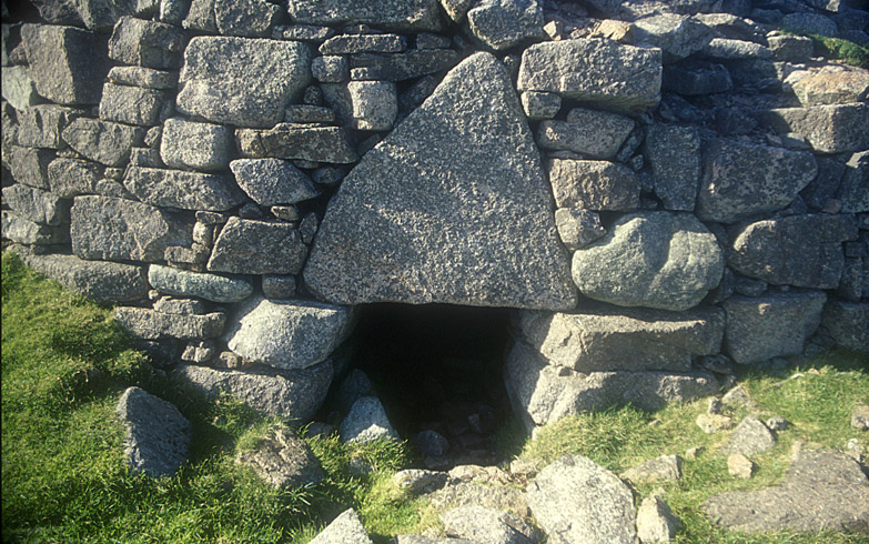
| The broch at Culswick is largely a pile of rocks. However, a few architectural features are visible, most notably this massive triangular lintel over the half-buried entrance. |
|
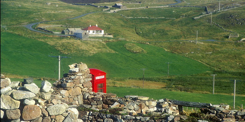
| Phonebox In The Middle Of Nowhere...a fairly common sight in rural Britain. Unlike in the US, the phone company in the UK is expected to maintain phone boxes in remote places. The more remote (and therefore unprofitable) the box is, the more vital it is in an emergency. This is the one at Culswick, at the beginning of the walk to the broch. The building it stands next to is a total ruin, but the phone is fully functional. |
|
| Here's another pitmon in Shetland--precisely where, I could not say. |
|
|
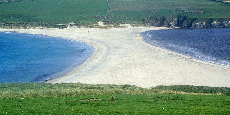
This peculiar formation is
called a tombolo. It's formed when currents swirl around either end of an
island, throwing up a beach between it and the mainland. The Scottish word is
ayre, which as I understand it includes any sort of barrier beach or
strand. This is the largest tombolo in Britain, connecting St. Ninian's Isle to
Mainland Shetland. For scale, note the little dark speck, which is a couple
walking on the beach. I am standing on the isle, near the site of St. Ninian's
Chapel, a 12th century ruin (pretty much just foundations) built atop an 8th
century ruin. In 1958, a schoolboy dug up a hoard of silver Pictish jewelry,
apparently hidden against marauding Vikings, which now resides in the Museum of
Scotland in Edinburgh. Replicas are in the Shetlands Museum in Lerwick.
I have my own treasure from St. Ninian's Isle--eight flat, oval, mica-flecked gray stones picked off the tombolo now lie at the bottom of the livingroom aquarium, along with razor clam shells from Camusdarroch Beach ("Ben's Beach" in Local Hero) and limpet shells from several Scottish beaches. |
|
|
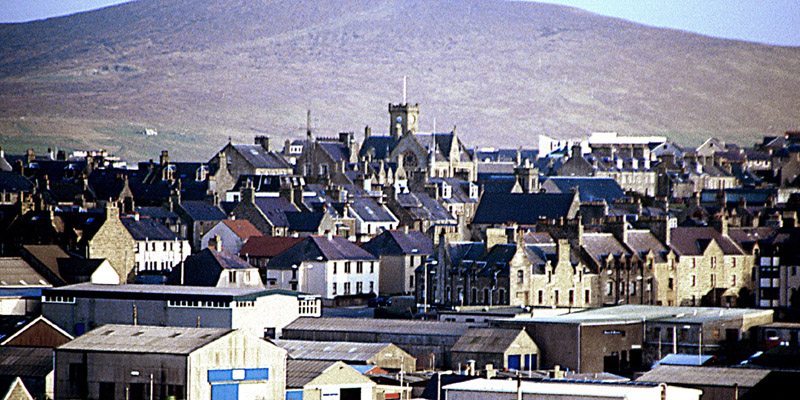
Lerwick (rhymes with Air Wick) is the largest town in
Shetland--indeed, the only town (Scalloway, the second largest locality, is
classified as a village). It's a lot like Stromness in Orkney, stonebuilt like
most any Scottish town, but with a decidedly Scandinavian tinge to it. Unlike in
Stromness, most of the stretch of houses originally fronting on the water have
been corraled by the modern road and commercial wharf. Commercial Street, set
one row back from the water, is semi-pedestrianized, a narrow, twisting lane
like the main street in Stromness. A dozen narrow alleyways, called wynds or
closes, lead from Commercial Street up over the hill to the back side of town. I
tried to take a different one back to the B&B each night after pints and
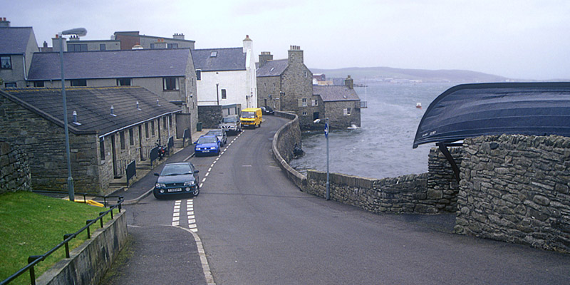
drams in The Lounge Bar. In this photo, you can see one house at the end of a short row that is still washed by the tides. The boat-topped structure on the right is a garage. Note that all the cars are parked facing the wrong way--this is legal in the UK, and normally a row of cars like this will be randomly arranged, like some sort of binary code. These guys are all zeroes. |

|
| Here's a black-and-white shot of the Lerwick waterfront, taken from the pier. The smaller houses seen here would originally have been right on the water, before the addition of the main road and the modern wharves. The larger building on the right appears to me to be considerably more recent, although I don't know for sure. The practice of setting the houses gable-end to the water is common in the Northern Isles and other Scandinavian-influenced parts of Scotland. It allows more houses to front on the water, as well as exposing less of each house to heavy weather. The building at the top of the hill houses the Shetland Museum. |
|
| As the capital of Shetland, Lerwick has suffered some of the same kind of modernization as Kirkwall in Orkney. But, as in Kirkwall, the changes haven't been overwhelming, and Lerwick compares fairly favorably with Stromness in Orkney for architectural charm. |
|
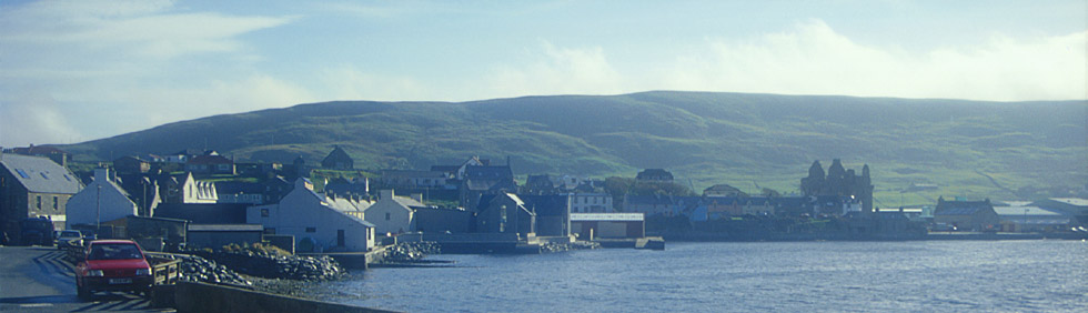
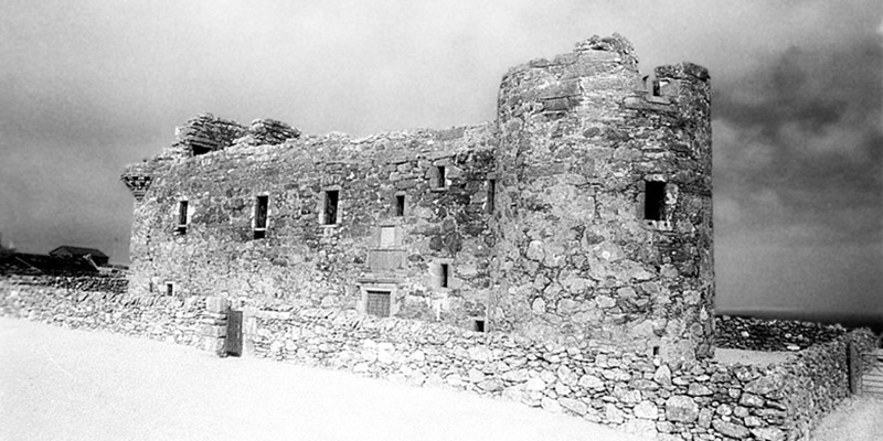
| The VisitShetland website says that Scalloway is a village, not a town. Whatever. Its 1,000+ population is certainly dwarfed by the mighty megalopolis of Lerwick, pop.7,500. (Shetland as a whole claims 22,000 inhabitants, more than half of whom live within a ten-mile radius of the center of Lerwick.) But Scalloway, on the west side of Mainland Shetland, was once the capital. The notorious Earl Patrick Stewart built a castle here, seen on the right in this photo. Stewart was an extravagant tyrant who was despised throughout the Northern Isles. He also built the Earl's Palace in Kirkwall in Orkney, and several other castles. He was found guilty of treason and beheaded in 1615. |
|
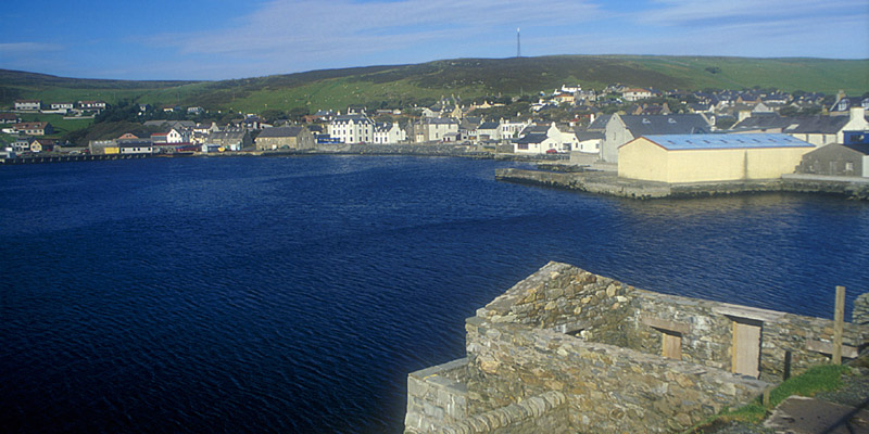
| A view of Scalloway from the other end of town, near the castle. Linda, the lovely barmaid at The Lounge Bar in Lerwick, told me of some ancient relative of hers who lived on Trondra, an island quite close to Scalloway. He was in the habit of rowing over to the pub in the Scalloway Hotel daily, even after a causeway was built, giving a quicker approach--he never trusted the causeway, short as it was. (Or maybe he didn't trust his ability to get across the causeway after visiting the pub.) He continued the practice until just a few days before his death. |
|

|
| The remains of the evil Earl Patrick Stewart's castle at Scalloway. The door is locked, the key available at the Scalloway Hotel. After walking all about the outside, I went to the Hotel to pick up the key, only to be told that someone had already done so. I walked back to the castle and found the door hanging eerily open...I had the feeling that I was in the middle of some Myst-like game. |
|
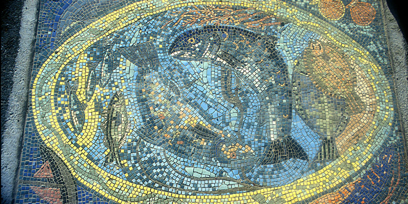
| This mosaic is set in the sidewalk on the Scalloway waterfront, near the castle. Unfortunately, I don't recall anything about its history. |
|
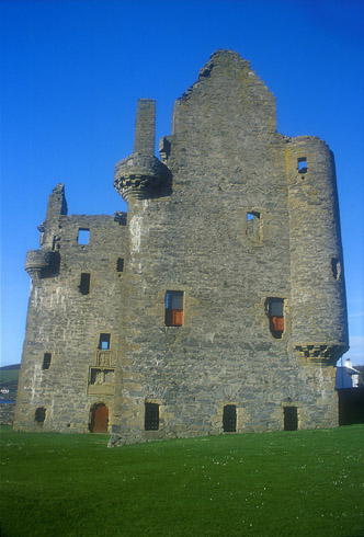
| From mainland Shetland, it's a short ferry ride to the island of Yell, and another short one to Unst, the most northerly inhabited land in Britain. A few miles off the main road is Muness Castle, built by one Laurence Bruce in 1598. Apparently Bruce set himself up in remote Shetland after having been implicated in a murder in his native Perthshire. It's the most northerly castle in Britain; in fact, about everything you see in this neighborhood is the most northerly whatever in Britain. The castle is a rather small Z-plan affair. It has not snowed; grass and other green foliage, oddly enough, reflect a lot of infrared light, and so usually show up white on infrared film. |
|
|
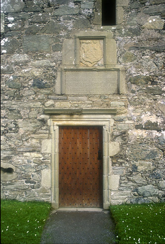
Here's the door to
Muness Castle. Compare to the one at Scalloway, above. While these castles are
ruins, having lost all their timberwork (roof and floors), the walls are
essentially intact, and in fact must be maintained by Historic Scotland, or
whoever owns the particular castle. Access is by key through doors such as this.
As noted, the key for Scalloway is kept at a nearby hotel, but the one for
Muness, like the one for Noltland Castle on Westray in Orkney, hangs by the door
of a neighboring house. I suppose the keeper of the key takes it in at night to
prevent vandalism. Muness Castle lies at the end of a spur road at the southern end of the island of Unst. (Cursed-end Unst? Ow.) Back on the main road, you can drive north through the village of Baltasound, where stands the Baltasound Hotel, the northernmost hotel in Britain. At Haroldswick, the road forks; if you were to bear right on the B 9087 (which I did not), you would shortly be on the northernmost bit of road in Britain, ending at Skaw, where you could see the northernmost house in Britain. Bear left instead on the B 9086, and the road will end just up the west side of the Burra Firth, at the parking lot for the Herma Ness Nature Reserve. From here you may hike to the northernmost point of Unst. It's a loop trail, and, because I wasn't sure how long it would take, I took the loop in reverse to the recommended direction, as it goes directly up over Hermaness Hill to the northernmost point that way, and I figured I could turn around and retrace my steps if I ran short of time. As it happened, I had plenty of time to complete the loop, but, traveling in the direction I was, I lost the trail. I had a choice of two small valleys to go up. The right-hand one looked more likely, but if it was wrong, I'd be outside the loop and hopelessly lost. If the left-hand trail was wrong, I'd be within the loop, and would eventually hit the proper trail again sooner or later. So up the left-hand valley I went. It wasn't long before I realized I'd made a mistake, and a bigger one than I'd thought; I was on very boggy ground. I stepped across what looked like a shallow puddle. My right leg was in up to the knee before I could flop backward onto dry land. In that short moment I thought of the 900-year-old guy a peat cutter had found in Caithness a few years back, perfectly preserved in the highly acidic bog. They'd never have found me--no one cuts peat in a nature reserve. Then there was another moment of panic when I tried to pull my foot out, and felt the suction tugging at my shoe. When I was about four or five, I'd lost a shoe down by the local mill pond in a similar manner, an incident I recall more from hearing about it endlessly from my family in the intervening 45 years, than from actual memory. I found that if I pulled up slowly, water flowed in underneath my foot, and shortly I was free. I carefully picked my way back to the parking lot (step, squish, step, squish, step, squish), where, fortunately, I had a change of trousers, socks, and shoes in the car. One good thing about traveling to a remote place like this in late September is that you can take off your pants in the parking lot of a nature reserve, and likely there's no one within five miles to notice. Made it back to Lerwick, via the two ferries, in time for dinner. That night in The Lounge Bar, I wrote a postcard to my mother, in which I informed her that I still had both of my shoes. |
|
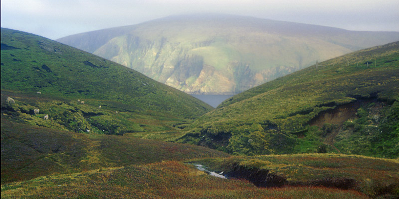
| Anyway, to back up a bit, along the trail between the parking lot and the top of Hermaness Hill, I had this view across the Burra Firth. From the summit dome of Hermaness Hill, the land slopes toward the cold northern sea, gently at first, but increasingly steeply. It's hard to say where the hillside comes to an end and the cliff begins, unless it's where the grass stops growing; you don't want to go that far. In fact, the sign back in the parking lot emphatically warns the walker not to wear waterproof trousers, lest, with a single misstep, he begin an uncontrollable slide on the wet grass that will inevitably end on the rocks far below (unless, of course, he happens to be carrying a hang glider). |
|
|
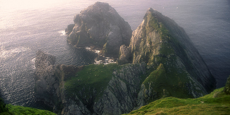
In
summertime, the cliffs and rocks are virtually carpeted with birds--puffins,
fulmars, kittiwakes, and others. By late September, only the wintering gannets
are left. If you look closely, you can see quite a lot of them dotting these
rocks, particularly the jutting rock to the left. The only other bird I
encountered at Herma Ness was a great skua, a largish, brown, eagle-like bird
that nests on the open ground. I suppose it's too big for the cliffs, and there
aren't any trees. They make strafing runs at intruding humans, but at this time
of year, they aren't very serious. Walkers in nesting season are advised to
carry a long stick. Now I have walked as far north as it is possible to walk. The GPS reads 60°50' and change, which won't impress any Norwegians; I am barely farther north than Bergen and Oslo, which are in southern Norway. I am also three or four degrees south of Reykjavik. But I am a hair farther north than Whitehorse, Yukon, and only twenty miles or so south of the latitude of Anchorage, Alaska. I am also about a thousand miles farther north than either Quebec City or Seattle. |
|
|
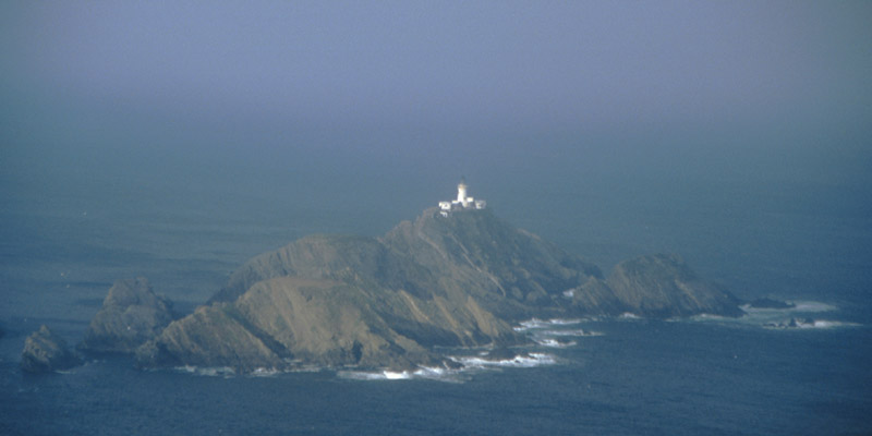
The rock below me is
called Muckle Flugga. The lighthouse on it is, you guessed it, the northernmost
lighthouse in Britain. In fact, it's the northernmost anything in Britain, save
for a jagged rock called the Out Stack a few hundred yards beyond (not visible
here). Beyond that lie only water and ice all the way to the pole, although you
wouldn't have to deviate too far from true north to land at Spitsbergen instead.
The lighthouse was built by Thomas Stevenson, father of Robert Louis Stevenson,
in the 1850s. (It's said that the map in Treasure Island looks a lot like the
map of Unst.) The keeper would have been Britain's northernmost resident, before
the light was automated in the 1960s. And that's it--the end of Unst, the end of Shetland, the end of the earth. Nothing left to do but turn around and walk back...through the northernmost bog in Britain. Fin |
The North Atlantic Arc Home
Mr Tattie Heid's Mileage
Results may vary